Welcome to DU!
The truly grassroots left-of-center political community where regular people, not algorithms, drive the discussions and set the standards.
Join the community:
Create a free account
Support DU (and get rid of ads!):
Become a Star Member
Latest Breaking News
Editorials & Other Articles
General Discussion
The DU Lounge
All Forums
Issue Forums
Culture Forums
Alliance Forums
Region Forums
Support Forums
Help & Search
General Discussion
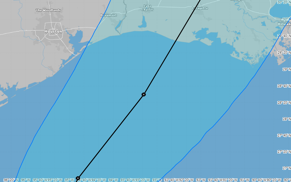
Related: Editorials & Other Articles, Issue Forums, Alliance Forums, Region ForumsTropical Update...heads up Louisiana
Forecast Track of likely Francine
https://www.nhc.noaa.gov/refresh/graphics_at1+shtml/095139.shtml?cone#contents
5 replies
 = new reply since forum marked as read
Highlight:
NoneDon't highlight anything
5 newestHighlight 5 most recent replies
Tropical Update...heads up Louisiana (Original Post)
surfered
Sep 2024
OP
Tropical storm likely to remain offshore from Texas, ultimately strike Louisiana
LetMyPeopleVote
Sep 2024
#2
Tropical Storm Francine has formed in the southern Gulf, according to the National Hurricane Center.
LetMyPeopleVote
Sep 2024
#3
malaise
(279,504 posts)1. Lots of life threatening storm surge and flooding for Texas as well
This is a very slow moving storm and it will be Francine shortly

LetMyPeopleVote
(156,305 posts)2. Tropical storm likely to remain offshore from Texas, ultimately strike Louisiana
This is encouraging for Texas but may be bad for Louisiana
Link to tweet
https://spacecityweather.com/tropical-storm-likely-to-remain-offshore-from-texas-ultimately-strike-louisiana/
We have been saying for a couple of days that this system will move near the South Texas coast by Tuesday, but then is likely to remain off the coast as it turns northeast. Almost all of the computer modeling that matters continues to point toward this scenario, which would keep impacts in Houston at a modest level. The forecast could still change, but time is running out for this to happen.

So what will this mean for the greater Houston area? Our region is likely to see elevated rain chances on Tuesday afternoon, night, and Wednesday, especially for locations south of Interstate 10. In terms of accumulations, we still need to watch the development of the system, but at this time I don’t anticipate the potential for much, if any flooding, with the possible exception of areas immediately along the coast. As for areas inland of Interstate 10, the rain potential is significantly less.

So what will this mean for the greater Houston area? Our region is likely to see elevated rain chances on Tuesday afternoon, night, and Wednesday, especially for locations south of Interstate 10. In terms of accumulations, we still need to watch the development of the system, but at this time I don’t anticipate the potential for much, if any flooding, with the possible exception of areas immediately along the coast. As for areas inland of Interstate 10, the rain potential is significantly less.
LetMyPeopleVote
(156,305 posts)3. Tropical Storm Francine has formed in the southern Gulf, according to the National Hurricane Center.
Solly Mack
(93,325 posts)4. We're already under a flood watch. Rain to begin tomorrow and continue for three days. We're not dried out
from the last heavy rain. Ground is still moist.
If it continues its projected path, we'll be just on the outskirts of it. Rain, yes but no damaging winds.
Louisiana.
surfered
(4,102 posts)5. Good luck. ps: I miss Bloom County

