Winter storm warning issued for several inches of wet snow in Roanoke/NRV area early Monday
TOP STORY | BREAKING
Winter storm warning issued for several inches of wet snow in Roanoke/NRV area early Monday
Kevin Myatt 5 hrs ago

The first weekday morning of 2022 looks to be a messy or beautiful one, depending on your personal take, making a decisive turn from the unseasonably warm weather of the holiday season to what may well be one of the larger winter storms of the past three years.
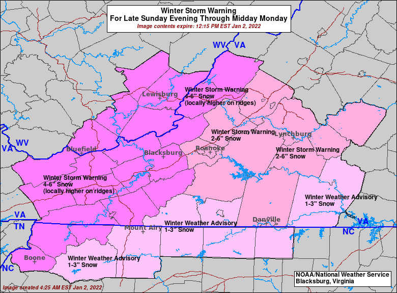
The National Weather Service has issued a winter storm warning encompassing the Roanoke Valley and all surrounding localities for Monday morning, as a strong low-pressure system moving along a stalling cold front to our south pulls colder air into it rapidly overnight, changing rain to wet snow in the early morning hours of Monday and continuing until mid-late morning, heavy at times.
Because of prior wet, warm ground, snow will accumulate unevenly, more on grassy areas vs. open ground or pavement, more in higher elevations than lower ones, generally more in rural ares vs. urban ones. Snow will collect far more readily on tree limbs and power lines, posing the risk of tree damage and power outages.
Generally, widespread accumulations of 3-6 inches are expected, but there could be variance with a little less possible in some of the lowest elevations of the Roanoke Valley near downtown and the river, and some lower areas east of the Blue Ridge, and a little more in the higher elevations or wherever heavier banding sets up. Some forecast models do suggest the potential for 6-10 inches in our region, though even if that does come the fruition, the first inch or 2 may be lost to initial melting.
{snip}
You didn't really think this kinda thing was going to hold off all winter, did you?
Contact Kevin Myatt at kevin.myatt@roanoke.com. Follow him on Twitter
@kevinmyattwx.
