American History
Related: About this forumOn this day, June 5, 1976, the Teton Dam failed.
Sun Jun 5, 2022: On this day, June 5, 1976, the Teton Dam failed.

Catastrophic failure on June 5, 1976
Location: Fremont & Madison counties, Idaho
Coordinates: 43°54′35″N 111°32′21″W
Purpose: Flood control, irrigation
Construction began: 1972
Opening date: 1976
Demolition date: June 5, 1976 (failure)
The Teton Dam was an earthen dam on the Teton River in Idaho, United States. It was built by the Bureau of Reclamation, one of eight federal agencies authorized to construct dams. Located in the eastern part of the state, between Fremont and Madison counties, it suffered a catastrophic failure on June 5, 1976, as it was filling for the first time.
The collapse of the dam resulted in the deaths of eleven people and 16,000 livestock. The dam cost about $100 million to build and the federal government paid over $300 million in claims related to its failure. Total damage estimates have ranged up to $2 billion. The dam has not been rebuilt.
{snip}
Collapse and flood

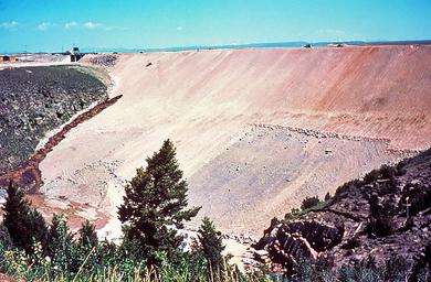
The dark brown streak on the dam face near the gray bedrock in the left half of the photo is a leak that formed on the morning of June 5. The speck above the leak near the top of the dam is a D9 bulldozer on its way to push soil into the leak.

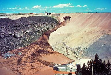
Large amounts of mud are now spilling down the face of the dam, unchecked by the efforts of the bulldozer operators. The outlet works at the foot of the dam are flooding with muddy water.

The dam is now breached and muddy water flows violently over the dam face.

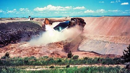
The breach has now widened to nearly its full extent. The outlet works are completely inundated with muddy water.

The reservoir emptying through the failed dam
On Saturday, June 5, 1976, at 7:30 am MDT, a muddy leak appeared, suggesting sediment was in the water, but engineers did not believe there was a problem. By 9:30 am, the downstream face of the dam had developed a wet spot, which began to discharge water at 20 to 30 cubic feet per second (0.57 to 0.85 m3/s) and the embankment material began to wash out. Crews with bulldozers were sent to plug the leak, but were unsuccessful. Local media appeared at the site and at 11:15, officials told the county sheriff's office to evacuate downstream residents. Work crews were forced to flee on foot as the widening gap, now larger than a swimming pool, swallowed their equipment. The operators of two bulldozers caught in the eroding embankment were pulled to safety with ropes.
At 11:55 am MDT (UTC−17:55), the crest of the dam sagged and collapsed into the reservoir; two minutes later, the remainder of the right-bank third of the main dam wall disintegrated. Over 2,000,000 cubic feet per second (57,000 m3/s) (many times the average flow rate of Niagara Falls) of sediment-filled water emptied through the breach into the remaining 6 miles (10 km) of the Teton River canyon, after which the flood spread out and shallowed on the Snake River Plain. By 8:00 pm, the reservoir had completely emptied, although over two-thirds of the dam wall remained standing.
{snip}
Deaths, damage, and property claims

Rexburg flooded

Teton Dam ruins in 2004
Teton Canyon ends about six miles (10 km) below the dam site, where the river flows onto the Snake River Plain. When the dam failed, the flood struck several communities immediately downstream, particularly Wilford at the terminus of the canyon, Sugar City, Salem, Hibbard, and Rexburg. Thousands of homes and businesses were destroyed. The small agricultural communities of Wilford and Sugar City were wiped from the river bank. Five of the eleven deaths attributed to the flood occurred in Wilford. The similar community of Teton, on the south bank of the river, is on a modest bench and was largely spared. One Teton resident was fishing on the river at the time of the dam failure and was drowned. An elderly woman living in the city of Teton died as a result of the evacuation.
{snip}
2naSalit
(95,027 posts)I wasn't a resident of Idaho at the time but when I did live there I was not far downriver (Snake) from there. Been through Sugar city many, many times as well as Rexburg, used to haul spuds out of there. In Rexburg, the surviving building all have the high water mark identified and there is a museum dedicated to the memory of the flood. The mormon temple there, the old one, is one of the oldest buildings that was flooded but it was not so deep that the important parts were damaged, though.
marble falls
(62,995 posts)2naSalit
(95,027 posts)Then went to Blackfoot to get a load soon afterward. I headed east out of IF on US26 so I don't think I was near anywhere that I could actually see damage from that. It was a while ago after all.
