Welcome to DU!
The truly grassroots left-of-center political community where regular people, not algorithms, drive the discussions and set the standards.
Join the community:
Create a free account
Support DU (and get rid of ads!):
Become a Star Member
Latest Breaking News
Editorials & Other Articles
General Discussion
The DU Lounge
All Forums
Issue Forums
Culture Forums
Alliance Forums
Region Forums
Support Forums
Help & Search
American History
Related: About this forumOn this day, August 23, 1933, the Chesapeake-Potomac hurricane made landfall on the Outer Banks.
1933 Chesapeake–Potomac hurricane

Surface weather analysis of the hurricane
shortly after landfall on August 23
Meteorological history
Formed: August 13, 1933
Extratropical: August 25, 1933
Dissipated: August 28, 1933
Category 4 hurricane
1-minute sustained (SSHWS/NWS)
Highest winds: 140 mph (220 km/h)
Lowest pressure: 940 mbar (hPa); 27.76 inHg
Overall effects
Fatalities: 47 total
Damage: $41.2 million (1933 USD)
Areas affected: North Carolina, Virginia, Washington, D.C., Maryland, Delaware, Mid-Atlantic States, Northeastern United States, Atlantic Canada
The 1933 Chesapeake–Potomac hurricane was among the most damaging hurricanes in the Mid-Atlantic states in the eastern United States. The sixth storm and third hurricane of the very active 1933 Atlantic hurricane season, it formed in the eastern Atlantic, where it moved west-northwestward and eventually became a Category 4 on the Saffir-Simpson hurricane wind scale. A strong ridge over New England allowed a continued northwest course, bringing the storm south of Bermuda and later toward the middle coast of the eastern United States. Advanced warning allowed hundreds of people to evacuate ahead of the hurricane making landfall. It did so in northeastern North Carolina on August 23 with winds of about 90 mph (140 km/h). Soon after, the eye crossed over Norfolk, Virginia, the first time that happened since 1821. The hurricane weakened into a tropical storm over northern Virginia shortly before passing near Washington, D.C., becoming the worst tropical cyclone there since 1896. Curving northward, the storm moved through Pennsylvania and New York before losing tropical characteristics on August 25. Now extratropical, the former hurricane moved across Atlantic Canada, dissipating on August 28.
Across the eastern United States, the hurricane left widespread damage amounting to over $40 million (equivalent to about $800 million in 2020) and causing at least 47 deaths. Although the storm struck North Carolina, damage in the state totaled only about $250,000, largely to crops and transport. Along the Chesapeake Bay, the storm produced 100-year flooding from its storm surge, setting records that remained for 70 years. In Virginia, flooding covered downtown portions of Norfolk in the southeast and Alexandria in the north. Damage in the state was estimated at $17.5 million. Similarly heavy damage occurred in Maryland, including over $7 million to crops. High waves along the coast eroded beaches and created a new inlet at Ocean City. The highest rainfall associated with the hurricane was 13.28 in (337 mm) at York, Pennsylvania. In the state, the rains flooded several rivers which forced thousands to evacuate. In neighboring New Jersey, high waves wrecked boats and destroyed a fishing pier, while in New York, flooding caused traffic jams. In Atlantic Canada, heavy rainfall assisted firefighters in combating wildfires, and the associated winds caused isolated power outages.
Meteorological history
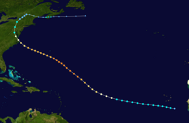
Map plotting the storm's track and intensity,
according to the Saffir–Simpson scale
Map key {snip}
On August 13, a tropical depression developed near the west coast of Africa, southeast of Cape Verde, with an associated closed circulation. Based on observations from a nearby ship, it is estimated the depression quickly intensified into a tropical storm while moving generally to the west-northwest. For several days the storm continued this general trajectory, eventually shifting more to the northwest. Based on interpolation of reports, it is estimated the storm intensified into a hurricane on August 16 while halfway between Africa and the Lesser Antilles. The Weather Bureau began tracking the system on August 18. Later that day, a ship reported a pressure of 948 mbar (28.0 inHg), suggesting winds of 135 mph (217 km/h). This made the hurricane a Category 4 on the Saffir-Simpson hurricane wind scale. Another ship report on August 20 indicated a pressure of 940 mbar (28 inHg) while reporting hurricane winds, suggesting peak winds of 140 mph (230 km/h).
After remaining near peak intensity for three days, the hurricane began steadily weakening while curving more to the west-northwest, a rare track for the region due to steering from a ridge over New England. On August 21, the storm passed about 150 mi (240 km) southwest of Bermuda. At 1000 UTC on August 23, the hurricane made landfall along the northern Outer Banks of North Carolina, near Nags Head, with a pressure of 963 mbar (28.4 inHg). Based on the steady weakening, coastal observations, and a larger than normal size, landfall winds were estimated at 90 mph (140 km/h). A few hours later, the hurricane made another landfall on the North Carolina mainland after crossing the Albemarle Sound. While the hurricane continued to the northwest, the eye briefly moved over Norfolk, Virginia, for the first time since the 1821 Norfolk and Long Island hurricane. Early on August 24, the hurricane weakened into a tropical storm while passing near Washington, D.C. Curving to the north, the storm crossed Pennsylvania and into New York, where it weakened further into a tropical depression. On August 25, the former hurricane turned to the east near the Canada–US border, and after interacting with a cold front, became extratropical. It emerged from Maine and briefly re-intensified, moving across southern Nova Scotia with gale-force winds. On August 28, the circulation dissipated to the south of Newfoundland.
{snip}
Surface weather analysis of the hurricane
shortly after landfall on August 23
Meteorological history
Formed: August 13, 1933
Extratropical: August 25, 1933
Dissipated: August 28, 1933
Category 4 hurricane
1-minute sustained (SSHWS/NWS)
Highest winds: 140 mph (220 km/h)
Lowest pressure: 940 mbar (hPa); 27.76 inHg
Overall effects
Fatalities: 47 total
Damage: $41.2 million (1933 USD)
Areas affected: North Carolina, Virginia, Washington, D.C., Maryland, Delaware, Mid-Atlantic States, Northeastern United States, Atlantic Canada
The 1933 Chesapeake–Potomac hurricane was among the most damaging hurricanes in the Mid-Atlantic states in the eastern United States. The sixth storm and third hurricane of the very active 1933 Atlantic hurricane season, it formed in the eastern Atlantic, where it moved west-northwestward and eventually became a Category 4 on the Saffir-Simpson hurricane wind scale. A strong ridge over New England allowed a continued northwest course, bringing the storm south of Bermuda and later toward the middle coast of the eastern United States. Advanced warning allowed hundreds of people to evacuate ahead of the hurricane making landfall. It did so in northeastern North Carolina on August 23 with winds of about 90 mph (140 km/h). Soon after, the eye crossed over Norfolk, Virginia, the first time that happened since 1821. The hurricane weakened into a tropical storm over northern Virginia shortly before passing near Washington, D.C., becoming the worst tropical cyclone there since 1896. Curving northward, the storm moved through Pennsylvania and New York before losing tropical characteristics on August 25. Now extratropical, the former hurricane moved across Atlantic Canada, dissipating on August 28.
Across the eastern United States, the hurricane left widespread damage amounting to over $40 million (equivalent to about $800 million in 2020) and causing at least 47 deaths. Although the storm struck North Carolina, damage in the state totaled only about $250,000, largely to crops and transport. Along the Chesapeake Bay, the storm produced 100-year flooding from its storm surge, setting records that remained for 70 years. In Virginia, flooding covered downtown portions of Norfolk in the southeast and Alexandria in the north. Damage in the state was estimated at $17.5 million. Similarly heavy damage occurred in Maryland, including over $7 million to crops. High waves along the coast eroded beaches and created a new inlet at Ocean City. The highest rainfall associated with the hurricane was 13.28 in (337 mm) at York, Pennsylvania. In the state, the rains flooded several rivers which forced thousands to evacuate. In neighboring New Jersey, high waves wrecked boats and destroyed a fishing pier, while in New York, flooding caused traffic jams. In Atlantic Canada, heavy rainfall assisted firefighters in combating wildfires, and the associated winds caused isolated power outages.
Meteorological history
Map plotting the storm's track and intensity,
according to the Saffir–Simpson scale
Map key {snip}
On August 13, a tropical depression developed near the west coast of Africa, southeast of Cape Verde, with an associated closed circulation. Based on observations from a nearby ship, it is estimated the depression quickly intensified into a tropical storm while moving generally to the west-northwest. For several days the storm continued this general trajectory, eventually shifting more to the northwest. Based on interpolation of reports, it is estimated the storm intensified into a hurricane on August 16 while halfway between Africa and the Lesser Antilles. The Weather Bureau began tracking the system on August 18. Later that day, a ship reported a pressure of 948 mbar (28.0 inHg), suggesting winds of 135 mph (217 km/h). This made the hurricane a Category 4 on the Saffir-Simpson hurricane wind scale. Another ship report on August 20 indicated a pressure of 940 mbar (28 inHg) while reporting hurricane winds, suggesting peak winds of 140 mph (230 km/h).
After remaining near peak intensity for three days, the hurricane began steadily weakening while curving more to the west-northwest, a rare track for the region due to steering from a ridge over New England. On August 21, the storm passed about 150 mi (240 km) southwest of Bermuda. At 1000 UTC on August 23, the hurricane made landfall along the northern Outer Banks of North Carolina, near Nags Head, with a pressure of 963 mbar (28.4 inHg). Based on the steady weakening, coastal observations, and a larger than normal size, landfall winds were estimated at 90 mph (140 km/h). A few hours later, the hurricane made another landfall on the North Carolina mainland after crossing the Albemarle Sound. While the hurricane continued to the northwest, the eye briefly moved over Norfolk, Virginia, for the first time since the 1821 Norfolk and Long Island hurricane. Early on August 24, the hurricane weakened into a tropical storm while passing near Washington, D.C. Curving to the north, the storm crossed Pennsylvania and into New York, where it weakened further into a tropical depression. On August 25, the former hurricane turned to the east near the Canada–US border, and after interacting with a cold front, became extratropical. It emerged from Maine and briefly re-intensified, moving across southern Nova Scotia with gale-force winds. On August 28, the circulation dissipated to the south of Newfoundland.
{snip}
CAPITAL WEATHER GANG
Vintage photos: the 1933 Chesapeake Potomac hurricane – flooding in Washington, D.C.
By Jason Samenow
August 23, 2013 at 5:17 p.m. EDT
Eighty years ago today, the Chesapeake Potomac hurricane pushed a wall of water up the Potomac River and Chesapeake Bay. It also carved the inlet between Ocean City and Assateague Island, as Don Lipman described in his earlier post.
The incredible 11-12 foot storm surge that rushed up the Potomac river caused massive flooding in tidal areas of Alexandria and the District.
Related: If Hurricane Sandy had come south: the dramatic storm surge scenario for Washington, D.C.
The storm also dumped 6-10 inches of rain over the region leading to the flooding of creeks and streams.
On the Library of Congress’ Web site, CWG’s Kevin Ambrose discovered a set of archived photos documenting both the surge and stream flooding around the District.
I reproduce them here:
{snip}

Flood of August 23, 1933. Washington Monument
from south Ellipse. (Library of Congress)
By Jason Samenow
Jason Samenow is The Washington Post’s weather editor and Capital Weather Gang's chief meteorologist. He earned a master's degree in atmospheric science and spent 10 years as a climate change science analyst for the U.S. government. He holds the Digital Seal of Approval from the National Weather Association. Twitter https://twitter.com/capitalweather
Vintage photos: the 1933 Chesapeake Potomac hurricane – flooding in Washington, D.C.
By Jason Samenow
August 23, 2013 at 5:17 p.m. EDT
Eighty years ago today, the Chesapeake Potomac hurricane pushed a wall of water up the Potomac River and Chesapeake Bay. It also carved the inlet between Ocean City and Assateague Island, as Don Lipman described in his earlier post.
The incredible 11-12 foot storm surge that rushed up the Potomac river caused massive flooding in tidal areas of Alexandria and the District.
Related: If Hurricane Sandy had come south: the dramatic storm surge scenario for Washington, D.C.
The storm also dumped 6-10 inches of rain over the region leading to the flooding of creeks and streams.
On the Library of Congress’ Web site, CWG’s Kevin Ambrose discovered a set of archived photos documenting both the surge and stream flooding around the District.
I reproduce them here:
{snip}
Flood of August 23, 1933. Washington Monument
from south Ellipse. (Library of Congress)
By Jason Samenow
Jason Samenow is The Washington Post’s weather editor and Capital Weather Gang's chief meteorologist. He earned a master's degree in atmospheric science and spent 10 years as a climate change science analyst for the U.S. government. He holds the Digital Seal of Approval from the National Weather Association. Twitter https://twitter.com/capitalweather
CAPITAL WEATHER GANG
Eighty years ago today – the Chesapeake and Potomac hurricane
By Don Lipman
August 23, 2013 at 12:27 p.m. EDT

Via the Maryland Historic Society : “Ocean City, MD.
View of the damage after the hurricane of 1933,
A. Aubrey Bodine, 1933, MC8230-A, MdHS.”
It was considered the storm of the century by many people. Immense property losses added to the woes of the Great Depression. Many farmers, watermen, and merchants lost everything. Some smaller communities never completely recovered.
That was the way it was on August 23, 1933, as noted by Rick Schwartz, author of Hurricanes and the Middle Atlantic States, and referenced by Jason Samenow in his post of August 23. 2008, 75 years later.
Now, eighty years later, I will try to focus on other aspects of this great storm and its aftermath.
{snip}
Here is some incredible video footage, courtesy the Maryland Historical Society, showing the inlet being cut:
vimeo.com/70042665
{snip}
Eighty years ago today – the Chesapeake and Potomac hurricane
By Don Lipman
August 23, 2013 at 12:27 p.m. EDT
Via the Maryland Historic Society : “Ocean City, MD.
View of the damage after the hurricane of 1933,
A. Aubrey Bodine, 1933, MC8230-A, MdHS.”
It was considered the storm of the century by many people. Immense property losses added to the woes of the Great Depression. Many farmers, watermen, and merchants lost everything. Some smaller communities never completely recovered.
That was the way it was on August 23, 1933, as noted by Rick Schwartz, author of Hurricanes and the Middle Atlantic States, and referenced by Jason Samenow in his post of August 23. 2008, 75 years later.
Now, eighty years later, I will try to focus on other aspects of this great storm and its aftermath.
{snip}
Here is some incredible video footage, courtesy the Maryland Historical Society, showing the inlet being cut:
vimeo.com/70042665
{snip}
Wed Aug 23, 2023: On this day, August 23, 1933, the Chesapeake-Potomac hurricane made landfall on the Outer Banks.
Tue Aug 24, 2021: On August 23, 1933, the Chesapeake-Potomac hurricane made landfall in northeastern North Carolina.